Dear Aspirants,
In this article, we present a comprehensive study of the Mahanadi River System. This post includes key facts about the Mahanadi River and its tributaries, major industries, crops, geology, dams, and projects along the rivers’ banks and tributaries.
The Mahanadi River is very important in India. It is a lifeline for millions of people and a symbol of prosperity and heritage. This blog post will tell you about the different aspects of the Mahanadi River, from the industries it supports to the dams and projects that harness its power. We will also learn some interesting facts about the Mahanadi River.
The Mahanadi River is the longest in East Central India. It is about 560 miles long and has a drainage area of 51,000 square miles. The Mahanadi River is a very important source of water for irrigation, drinking, and industrial use. It also supports a variety of industries, including agriculture, mining, and tourism.
The Mahanadi River is home to many dams and projects that harness its power for various purposes. The most famous dam on the Mahanadi River is the Hirakud Dam, which is the largest dam in India. The Hirakud Dam is used for irrigation, hydroelectric power generation, and flood control.
The Mahanadi River is a very important part of India’s natural and cultural heritage. It is a source of livelihood for millions of people and a place of great beauty. The Mahanadi River is remarkable, and I hope you enjoy learning more about it.
✅ Explore the Complete List of Indian Geography Topics
The Majestic Mahanadi River System: Origin, Length, and Basin
▪ The Mahanadi River originates near Pharsiya village, Nagri town in Raipur district, Chhattisgarh, at an elevation of 442 meters above mean sea level.
▪ It stretches an impressive 900 km (560 miles) from its source to its confluence in the Bay of Bengal.
▪ Approximately 900 km of the river’s course is divided between the states of Chhattisgarh and Odisha.
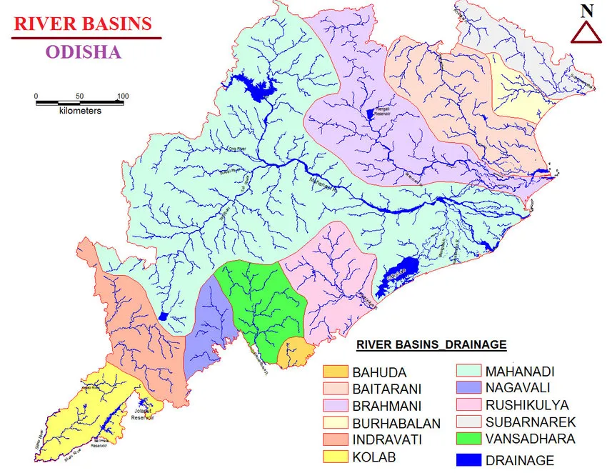
▪ The Mahanadi River ranks second in water potential among peninsular rivers, with only the Godavari River surpassing it.
▪ The river basin covers about 1,41,589 sq km, accounting for about 4.3% of India’s total geographical area.
▪ The Mahanadi basin is bordered by natural features, including the Central India hills to the north, the Eastern Ghats to the south and east, and the Maikala range to the west.
▪ The river basin extends its reach to multiple states, including Chhattisgarh, Odisha, Jharkhand, Maharashtra, and Madhya Pradesh.
| Name of State | Catchment Area |
|---|---|
| Chhattisgarh | 75,136 |
| Orissa | 65,580 |
| Bihar | 635 |
| Maharashtra | 238 |
▪ The basin also includes other small streams that drain directly into the Chilka Lake.
▪ The major part of the basin, about 54.27% of the total area, is covered with agricultural land.
▪ The Mahanadi River is known for its high silt-depositing activity in the Indian subcontinent. After receiving the Seonath River, it turns east and enters Odisha state.
▪ At Sambalpur, the Hirakud Dam dames the river, creating a 55 km long man-made lake.
▪ The Mahanadi River finally enters the Odisha plains near Cuttack and flows into the Bay of Bengal at False Point through several channels.
▪ Puri is a famous pilgrimage site at one of its mouths.
| Mahanadi River in a Nutshell | |
|---|---|
| River Name | Mahanadi |
| Origin | Pharsiya village, Nagri town, Raipur district, Chhattisgarh |
| Length | 900 kilometres (560 mi) |
| States it Flows Through | Chhattisgarh and Odisha |
| Length in Chhattisgarh | 357 Km |
| Length in Odisha | 494 Km |
| Water Potential Ranking | Second among peninsular rivers (after Godavari) |
| Ranking | Third largest river of peninsular India after Godavari and Krishna, and the largest river of Odisha state |
| Catchment Area | 132,100 square kilometres (51,000 sq mi) |
| Percentage of India’s Total Geographical Area Covered | 4.3% |
| Boundaries of Basin | North: Central India hills |
| South & East: Eastern Ghats | |
| West: Maikala range | |
| States in Mahanadi Basin | Chhattisgarh, Odisha, Jharkhand, Maharashtra, Madhya Pradesh |
| End Point | Bay of Bengal |
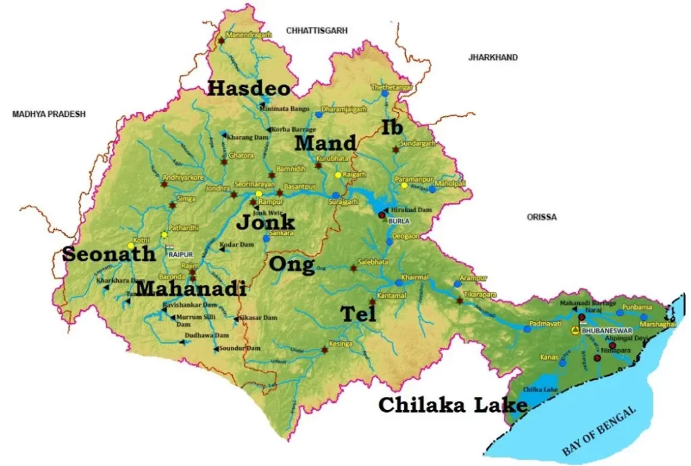
The Geographical Features of the Mahanadi River Basin
▪ The upper reaches of the Mahanadi basin lie on an undulating plateau adorned with hillocks.
▪ To the south of this plateau, an open expanse extends, flanked by hill ranges to the east and west.
▪ These hill ranges boast steep slopes, facilitating direct water drainage into the Mahanadi River.
▪ Furthermore, the Mahanadi basin, up to Manibhadra, maintains a continuous tilt towards the main valley, ensuring smooth water flow without experiencing drainage congestion.
Geology and Economic Activities in the Mahanadi Basin
▪ The catchment area of the Mahanadi River, extending up to Manibhadra, is primarily characterized by Archean terrain and gneiss rock formation.
▪ In this region, the hills are composed of igneous and metamorphic rocks, with significant types such as quartzite, phyllite, quartz schist, mica schist, and granite.
▪ Moreover, the sub-basin exhibits alluvial formations of recent origin, varying in thickness. This diverse geological landscape contributes to the formation of the Mahanadi River system.
Urban Centers and Industries in the Mahanadi Basin
▪ The Mahanadi basin houses several urban centres, including Raipur, Durg, and Cuttack. These cities serve as hubs of economic activities and development in the region.
▪ The basin is also home to various industries that are vital to the local economy. Notably, Bhilai hosts an Iron and Steel plant, while Hirakud and Korba boast prominent aluminium factories. Additionally, a paper mill near Cuttack and a cement factory in Sundargarh contribute to the industrial landscape.
▪ The region’s economic activities extend to sugar and textile mills and mining operations for coal, iron, and manganese. These industries drive economic growth and employment opportunities in the Mahanadi Basin.
Urban centres and industries in the Mahanadi Basin in a Nutshell
| Urban Center | State | Industry |
|---|---|---|
| Raipur | Chhattisgarh | Iron and steel, cement, power generation, IT, education |
| Bhilai | Chhattisgarh | Iron and steel |
| Durg | Chhattisgarh | Textiles, engineering, power generation |
| Cuttack | Odisha | Port, education, tourism, IT |
| Rourkela | Odisha | Steel, mining, power generation |
| Sambalpur | Odisha | Education, healthcare, tourism |
| Jharsuguda | Odisha | Coal mining, power generation |
| Korba | Chhattisgarh | Coal mining, power generation |
Major Dams/Projects on Mahanadi and Its Tributaries
The Mahanadi River basin comprises several significant dams, barrages, and reservoirs that serve various purposes, including irrigation, hydroelectric power generation, and flood control. Let’s explore some of the major dams on the Mahanadi River and its tributaries:
List of dams on Mahanadi River
| Dam/Project | State (District) | River | Purpose |
|---|---|---|---|
| Hirakud Dam | Odisha (Sambalpur) | Mahanadi | Irrigation, hydroelectric power generation |
| Hasdeo Bango Dam | Chhattisgarh (Bilaspur) | Hasdeo | Irrigation, hydroelectric power generation |
| Ravishankar Sagar Dam (Pandit Ravishankar Sagar) | Chhattisgarh ( Dhamtari ) | Mahanadi | Irrigation, drinking water |
| Dudhawa Reservoir | Chhattisgarh (Kanker) | Mahanadi | Irrigation, drinking water |
| Sondur Reservoir | Chhattisgarh ( Dhamtarid) | Sondur River | Irrigation, drinking water |
| Tandula Project | Chhattisgarh (Balod) | Mahanadi | Irrigation, drinking water |
| Gangrel Hydroelectric Project | Chhattisgarh (Raipur) | Mahanadi | Hydroelectric power generation |
| Sikaser Hydroelectric Project | Chhattisgarh (Bastar) | Pairi river | Hydroelectric power generation |
Hirakud Dam
▪ The Hirakud Dam, located on the Mahanadi River in Odisha, is one of India’s largest dams.
▪ Constructed in 1953, it fulfils essential functions such as flood control, irrigation, and power generation.
▪ Spanning 4.8 km with a maximum height of 60 meters, the dam creates the Hirakud Reservoir, Asia’s largest artificial lake, attracting tourists from far and wide.
▪ It is the longest earthen dam in the world.
▪ Hirakud Reservoir was declared a Ramsar site on 12 October 2021.
What is the main use of projects in the Mahanadi River Basin at present?
Various dams and multipurpose projects built over the Mahanadi River are mainly used for irrigation and hydroelectric projects.
The Mahanadi basin is home to several large-scale irrigation projects, such as the Hirakud Dam and the Rengali Dam, which provide water to over 2 million hectares of agricultural land.
The basin also has several hydropower projects, such as the Indravati Hydroelectric Project and the Upper Indravati Hydroelectric Project, which generate over 10,000 MW of electricity.
In addition to irrigation and hydropower, the projects in the Mahanadi River Basin also play an important role in flood control, drinking water supply, and navigation.
Soil Types and Agricultural Features in Mahanadi River Basin
Odisha
▪ The Mahanadi river basin in Odisha predominantly comprises red and yellow soils.
▪ Additionally, mixed red and black soils can be found in specific regions, specifically in parts of Bolangir, Sambalpur, and Sundargarh districts.
▪ In the lower areas of Odisha, laterite soil is commonly observed. Along the coastal plains of the Mahanadi, the soil type is deltaic soil, contributing to the unique agricultural landscape of the region.
Chhattisgarh
▪ The main soil types prevalent in the Mahanadi basin of Chhattisgarh are black and sandy soil, with occasional “Kankar.”
▪ The basin features an extensive forest cover, except in Chhattisgarh’s regions and Odisha’s coastal plains.
▪ Agriculture and forests form the backbone of the economy in the interior parts of the Mahanadi basin.
Agriculture in Chhattisgarh and Odisha
▪ The areas of Chhattisgarh and the coastal plains of Odisha receive substantial rainfall, making them predominantly rice-growing regions.
▪ The fertile land and adequate water supply from the Mahanadi River create favourable conditions for rice cultivation, contributing significantly to the agricultural output of these regions.
Major Tributaries of the Mahanadi River System
| Tributary | Joining Side | Length (km) |
|---|---|---|
| Seonath | Left | 383 |
| Jonk | Right | 292 |
| Hasdeo | Left | 452 |
| Mand | Left | 405 |
| Ib | Left | 292 |
| Ong | Right | 265 |
| Tel | Right | 254 |
| Pairi | Left | 170 |
| Shivnath | Left | 156 |
Tributaries of the Mahanadi River Facts
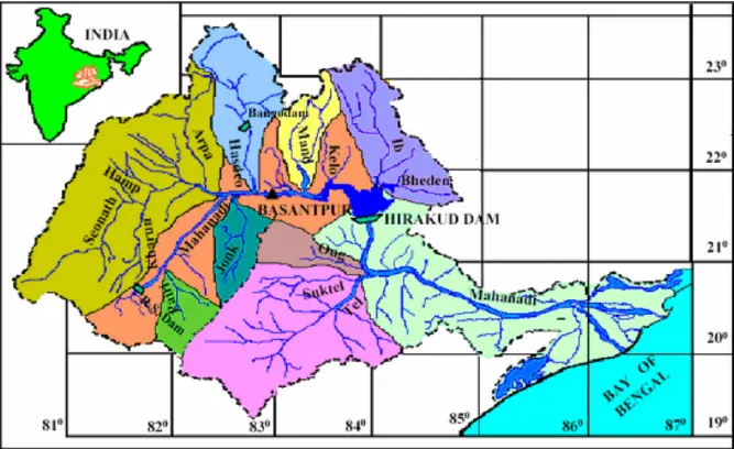
Left Bank tributaries:
- Seonath
- Hasdeo
- Mand
- Ib.
Right Bank tributaries:
- Ong
- Tel
- Jonk.
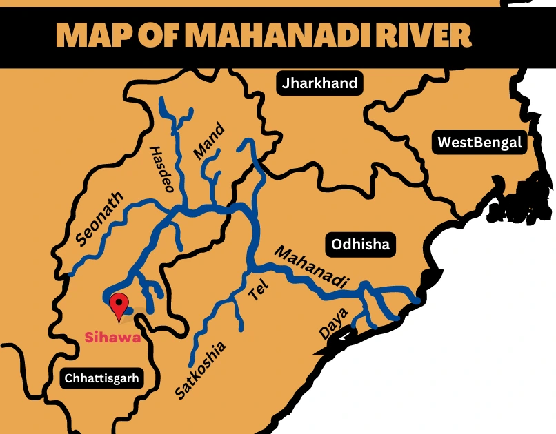
The Largest Tributary of Mahanadi
• The Hasdeo River is the largest tributary of the Mahanadi River.

• It rises in the Koriya district of Chhattisgarh.

• It flows for a length of 333 kilometers before joining the Mahanadi River at Shiladehi (Birra).

• The Hasdeo River drains an area of about 9,856 square kilometers.

• The Hasdeo River is an important source of water for irrigation, drinking water, and hydropower.

• It also flows through the Hasdeo Arand forest, which is one of the largest and most biodiverse forests in Central India.
Facts about Left Bank Tributaries
Seonath
▪ Seonath River also known as Shivnath River.
▪ It is the longest tributary of the mighty Mahanadi River.
▪ Its confluence is located in the Janjgir-Champa district of Chhattisgarh, India.
Origin and Course
▪ The river originates from the quaint village of Godari in the Gadchiroli district of Maharashtra.
▪ Its journey commences with a northeastern flow covering an impressive distance of 300 kilometres (190 miles) before gracefully merging with the Mahanadi River near Shivrinarayan in Chhattisgarh.
▪ Some accounts suggest an alternative origin at Panabaras Hill, rising 624 meters (2,047 feet) above sea level in the Ambagarh Chowki division of Rajnandgaon District in Chhattisgarh.
Significance and Name Origin
▪ The significance of the name “Shivnath” lies in its connection to the revered Hindu deity, Lord Shiva. As the river’s namesake, it carries an inherent spiritual significance and cultural value for the local communities.
Main Tributaries and Drainage Area
▪ On its right bank, Shivnath River receives contributions from the tributaries:
Kharhara
Tandula
Kharun.
▪ On the left bank, the notable sub-tributaries are:
Surh
Hanp
Agar
Arpa.
▪ The collective drainage area of the Seonath River spans nearly 30,761 square kilometres, constituting approximately 22% of the total drainage area of the Mahanadi basin.
▪ The Shivnath River, meandering through an undulating landscape dotted with small groups of hills near Kotgal at an elevation of around 533 meters, exemplifies the harmonious blend of nature’s beauty and human heritage.
▪ As it journeys onward, nurturing the lands it touches, the river is a testament to the vibrant spirit of India’s waterways and their role in shaping the nation’s diverse cultural and ecological tapestry.
Hasdeo River
Hasdo River Overview
▪ Hasdo River, also known as Hasdeo River.
▪ It is the largest tributary of the Mahanadi River.
▪ It flows through the state of Chhattisgarh, India.
▪ The river originates near Sonhat in the Sarguja district, at an elevation of approximately 915 meters (3,002 feet) above sea level.
▪ From its source, it traverses a length of about 333 kilometres (207 miles) before merging into the Mahanadi River near the village of Mahuadih.
Drainage Area and Tributary
▪ The total drainage area of the Hasdo River spans 9,856 square kilometres, accounting for about 6.96% of the Mahanadi basin area.
▪ The principal sub-tributary of the Hasdo River is the Gej River.
Project and Route
▪ The Hasdo River is harnessed by the Hasdo Bango Dam, constructed across its course.
▪ The river flows through the picturesque Hasdeo Arand forest, adding to its natural charm.
Confluence Point
▪ The Hasdo River merges into the Mahanadi River in Chandarpur, Chattisgarh, approximately 28 kilometres (17 miles) before the Mahanadi River reaches the Hirakud Dam.
Mand River
Mand River Overview
▪ The Mand River, a significant tributary of the Mahanadi in India, joins the Mahanadi near Chandarpur in Chhattisgarh, approximately 28 kilometres (17 miles) from the Odisha border and before the river reaches the Hirakud Dam.
Origin and Length
▪ The river originates in the Surguja district of Chhattisgarh, rising to an elevation of around 686 meters (2,251 feet).
▪ It travels a total distance of 241 kilometres (150 miles) from its source to the confluence with the Mahanadi on its left bank, near Chandarpur.
Catchment Area
▪ The Mand River’s catchment area encompasses nearly 5,200 square kilometres (2,008 square miles).
Principal Tributaries
▪ The main tributaries of the Mand River are as follows:
- Koirja nalla
- Gopal nalla
- Chhindai nalla
- Kurket river
Ib River
Ib River Overview
▪ The Ib River, a significant tributary of the Mahanadi River, flows through North-Eastern Central India and eventually joins the Mahanadi by directly flowing into the Hirakud Reservoir.
Origin and Course
▪ The river originates in the hills near Pandrapet at an elevation of approximately 762 meters (2,500 feet).
▪ It courses through the Raigarh and Jashpur districts of Chhattisgarh and the Jharsuguda and Sundargarh Districts of Odisha.
▪ The river journey culminates when it meets the Mahanadi at the Hirakud Dam in the state.
Industrial Significance
▪ The Ib River valley is renowned for its rich coal belt, hosting the Ib Valley Coalfield, and has become the backdrop for major portions of the Mahanadi Coalfields.
▪ Flourishing industries have emerged along the banks of the Ib River, making the Ib Valley an essential industrial zone in Eastern India.
River Length and Drainage Area
▪ The Ib River stretches for a distance of approximately 252 kilometres (157 miles) and drains an extensive area of 12,447 square kilometres (4,806 square miles).
Perennial Inspiration and Folklores
▪ The Ib River has served as a perennial source of inspiration for several tribal communities in Chhattisgarh and Odisha, who chose to establish permanent habitats along its banks in ancient times.
▪ The river’s allure has given rise to numerous folklores, perpetuating its mythological significance throughout the region.
Rain-fed River
▪ The Ib River is primarily rain-fed, with nearly 80% of its runoff occurring during the monsoon period.
Important Tributaries
▪ The main tributaries of the Ib River include:
- Maina
- Sapal
- Bheden
Facts about Right Bank Tributaries
Ong River
Ong River Overview
▪ The Ong River is an important tributary of the Mahanadi River, flowing across the picturesque landscapes of Odisha, India.
Origin and Course
▪ The river begins its journey at an elevation of 457 meters (1,499 feet) on a hill in the northern outskirts of the Gandhamardan ranges, located to the right of the Jonk River.
▪ It courses through a distance of 204 kilometres (127 miles) before gracefully joining the Mahanadi River on its right, approximately 11 kilometres (7 miles) from Sonepur.
Drainage Area
▪ The Ong River drains an expansive area of about 5,128 square kilometres (1,980 square miles).
Major Tributaries
▪ The major tributaries that contribute to the flow of the Ong River include:
- Chira nalla
- Surangi
- Utalioe
- Khira
Nearby Rivers
▪ The Ong River is surrounded by several nearby rivers, adding to the region’s water network:
- Tel Nadi – 76 kilometres (47 miles) away
- Gorkha Nadi – 171 kilometres (106 miles) away
- Subarnarekha River – 431 kilometres (268 miles) away
- Godavari – 485 kilometres (301 miles) away
- Manairu Vagu – 508 kilometres (316 miles) away
Climate and River Basin
The climate of the Ong River basin is mainly characterized as dry sub-humid, influencing the river’s flow and ecosystem.
Tel River
Tel River overview
▪ The Tel River gracefully winds its way through the scenic districts of Nabarangpur, Kalahandi, Balangir, Boudh, and Sonepur in Odisha, India, serving as an essential tributary of the Mahanadi River.
Origin and Course
▪ The river originates in the plain and open country in the Nabarangpur district of Odisha, near the Amravati forest range, close to the Odisha-Chhattisgarh border.
▪ From its source in the Koraput district of Odisha, nearly 32 kilometres (20 miles) west of Jorigam, it traverses a distance of 296 kilometres (184 miles) to reach its confluence with the Mahanadi River on its right bank, approximately 1.6 kilometres (1 mile) downstream from Sonepur.
Meeting Point and Scenic Beauty
▪ The Tel River joins the main Mahanadi River at Sonepur or Subarnapur, offering a breathtaking view amid a colourful landscape.
▪ On the left bank of the Tel River lies the Baidyanath Temple, renowned for the Kosaleshwar Shiva temple, adding a touch of spirituality to the scenic surroundings.
Principal Tributaries
▪ The Tel River is nourished by several principal tributaries, including:
- Udanti
- Indra
- Lant
- Sutkel
- Hatti
- Ret
- Uttei
- Raul
- Khadago
River Sub-basin and Drainage Area
▪ The Tel River sub-basin is roughly rectangular, encompassing an extensive drainage area of approximately 22,818 square kilometres (8,802 square miles).
Jonk river
Jonk River Overview
▪ The Jonk River, a significant tributary of the Mahanadi River, flows through the Nuapada District and Bargarh District in Odisha and the Mahasamund District and Raipur District in Chhattisgarh, India.
Origin and Course
▪ The river originates from the Sunabeda plateau in the Nuapada district of Odisha, at an elevation of 700 meters (2,297 feet).
▪ As it flows for approximately 210 kilometres (130 miles), it enters the Maraguda Valley, where it meets a stream called Gaidhas-nala near Patora village.
▪ Along its course, the river forms two picturesque falls, Beniadhas Fall (80 feet) and Kharaldhas Fall (150 feet), adding to the region’s natural beauty.
▪ Ultimately, the Jonk River joins the Mahanadi at Shivrinarayan.
Tributaries
▪ The Jonk River receives contributions from several important tributaries, including:
- Machkanalla
- Sukha nalla
- Kantra nalla
- Kermel nadi
- Ranidhara nalla
Drainage Area
▪ The Jonk River covers an area of about 3,484 square kilometres (1,344 square miles), which accounts for approximately 2.46% of the total area of the Mahanadi River basin.
Conclusion
The Mahanadi River System holds immense importance for the state of Odisha, playing a crucial role in its history, economy, and ecology. Addressing the challenges it faces requires a collaborative approach involving the government, civil society, and other stakeholders. Sustainable practices such as effective waste management, afforestation, and responsible agriculture can ensure the well-being of the river and its resources, benefiting both the present and future generations.
To preserve the river’s rich biodiversity, focusing on better managing dams and reservoirs is essential, ensuring their sustainable and equitable utilization. As a vital part of India’s natural heritage, the Mahanadi River deserves concerted efforts to secure its long-term sustainability. With proper conservation measures, it will continue to provide sustenance and livelihood for generations to come, becoming a testament to responsible resource management.
Frequently Asked Questions about the Mahanadi River System
Mahanadi River flows through the states of Odisha and Chhattisgarh in India.
The Mahanadi River flows through the states of Odisha and Chhattisgarh in India.
Mahanadi River originates from the state of Chhattisgarh in India.
Mahanadi River originates from the Sunabeda plateau in the state of Chhattisgarh.
During different periods, it was referred to by different names such as Kanak Nandini, Chitrotpala, Nilotpala, Mahananda, and Mahanadi or Mahashweta. In Vayu Puran river Mahanadi was stated as Nilotpala. In Matsya Puran river Mahanadi was stated as Chitrotpala.
The Mahanadi River is the largest in Odisha.
The Hirakud Dam is built on the Mahanadi River.
