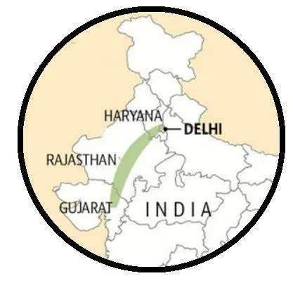
The Aravalli Range is one of the oldest mountain ranges in India, stretching approximately 670 kilometers from Gujarat in the southwest to Delhi in the northeast. This unique geological formation plays a crucial role in India’s geography, influencing the climate, biodiversity, and water resources of the region.
The Aravallis are not only significant for their natural beauty but also for their rich history and cultural heritage. The range is home to the highest peak, Guru Shikhar, which reaches an elevation of about 1,722 meters.
✅ Explore the Complete List of Indian Geography Topics
Understanding the Aravalli Range is essential for students preparing for competitive exams like SSC, UPSC, RRB NTPC, CDS, and various state-level tests, as questions about its features, ecological importance, and historical significance are commonly asked. In this blog post, we will explore the key aspects of the Aravalli Range, its biodiversity, the challenges it faces, and its importance in Indian geography.
Overview of Aravalli Range
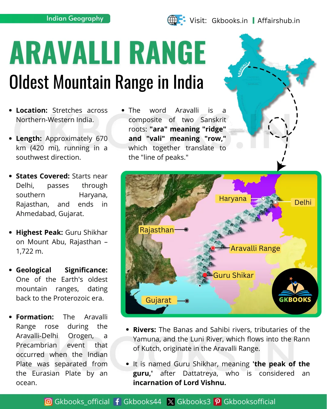
- Location: The Aravalli Range is situated in Northern-Western India.
- Length: It stretches approximately 670 km (420 mi) in a southwest direction.
- Geographical Coverage: The range starts near Delhi, passes through southern Haryana and Rajasthan, and ends in Ahmedabad, Gujarat.
- Highest Peak: The tallest peak in the range is Guru Shikhar, located in Mount Abu, standing at an elevation of 1,722 m (5,650 ft).
- Geological Significance: The Aravalli Range is among the oldest geological formations on Earth, dating back to the Proterozoic era.
- Natural Resources: It is rich in various natural resources, contributing to the local economy.
- Environmental Impact: The range acts as a barrier to the expansion of the Thar Desert in western India, influencing the region’s climate and ecology.
Meaning of the term “Aravalli”
The term “Aravalli” is derived from Sanskrit, combining the roots “ara” and “vali,” which translates to “line of peaks.”
Geology and Significance
India’s Oldest Mountains
The Aravalli Range is known as the oldest fold mountain range in India. It is located in the northwestern part of the Indian Peninsula.
These mountains are remnants of ancient hills that have been worn down over millions of years. In the past, they were much taller than they are today.
Formation of the Aravalli Range
The history of the Aravalli Range goes back to a time when the Indian Plate was separated from the Eurasian Plate by an ocean.
The formation of these mountains is linked to an event called the Aravalli-Delhi Orogeny, which happened during the Precambrian era.
This process is similar to how the younger Himalayas are still rising today, but the Aravalli Range has stopped growing higher because the forces pushing them up have ceased.
Ancient Geological History
The Aravalli Range connects two ancient segments of the Earth’s crust:
- Aravalli Craton: Located to the northwest, this segment is part of the greater Indian craton.
- Bundelkand Craton: Found to the southeast, this is another ancient crust segment.
Cratons are old and stable parts of the Earth’s crust that have not changed much over time, even during shifts in the Earth’s continents.
Geological Processes Involved
The Aravalli Range has gone through many geological processes over its long history:
- Metasedimentary and Metavolcanic Rocks: The Aravalli and Delhi Supergroups consist of two main types of rocks. Metasedimentary rocks are sedimentary rocks that have changed due to pressure and heat, while metavolcanic rocks are altered volcanic rocks.
- Formation of the Bhilwara Gneissic Complex: Underneath these supergroups is the Bhilwara Gneissic Complex, which formed about 4 billion years ago. This complex is made up of high-grade metamorphic rocks.
Tectonic Activity and Rifting
The Aravalli Range was formed through a series of tectonic activities:
- Passive Rifting (2.5 to 2.0 billion years ago): This process began when the Archaean continent started to pull apart.
- Active Rifting (1.9 to 1.6 billion years ago): The land continued to separate and shaped the current structure of the mountains.
As these tectonic plates moved, they caused various geological events, such as the formation of volcanic arcs and the collision of oceanic and continental plates.
Minerals of the Aravalli Range
Aravalli Basement
- The Aravalli Range is built on a strong base known as the Archean basement.
- This ancient layer of rock has shaped the mountains’ overall structure.
- The base rocks, called Mewar Gneiss, were formed through intense heat and pressure from older sedimentary rocks that existed during the Archean Eon.
- These rocks contain fossils of some of the earliest life forms, like green algae and cyanobacteria, which were found in ancient reefs known as stromatolites.
Types of Mineral Deposits
- In the Aravalli region, there are also special deposits known as sedimentary exhalative deposits.
- These deposits include base metal sulfide ores and can be found in long, narrow zones within the Bhilwara aulacogen.
- They formed in areas where rich stromatolitic phosphorites also developed.
Formation of Metal Ores
The Aravalli Mountains have a complex history of mineral formation:
- Lead and Zinc Ores: These metal ores were created around 1.8 billion years ago during the Paleoproterozoic phase. They formed within sedimentary rocks.
- Zinc-Lead-Copper Ores: In the Delhi Supergroup rocks found in areas like Haryana and Delhi, these ores resulted from volcanic activity caused by a mantle plume about 1 billion years ago. This activity spread across parts of Haryana and Rajasthan during the Mesoproterozoic era.
- Tungsten and Tin Ores: These minerals formed near subduction zones, where one tectonic plate moves under another. The continued subduction led to the creation of minerals in different rock types, including S-type (sedimentary), felsic (volcanic), and plutons (solidified magma).
Commercially Important Minerals
The Aravalli Range is rich in various minerals that have commercial value. Some of these include:
- Rock Phosphate
- Lead-Zinc-Silver Deposits (found in places like Zawar)
- Rikahbdev Serpentinite
- Talc
- Pyrophyllite
- Asbestos
- Apatite
- Kyanite
- Beryl
Mining in the Aravalli Range
Ancient Copper Mining
The Aravalli Range has a long history of mining, especially for copper and other metals. Archaeological evidence shows that mining activities date back to at least the 5th century BCE. This means people have been extracting minerals from these mountains for thousands of years.
Early Mining Activities
Recent research suggests that copper mining in the Aravalli Range started even earlier, during the Sothi-Siswal period, around 4000 BCE. This indicates that ancient people were already using copper from this region for tools, jewelry, and other purposes.
Settlements and Copper Usage
Settlements like Kalibangan and Kunal in Haryana relied on copper mined from the Aravalli Range. These ancient communities were among the first to utilize the resources found in these mountains, showcasing the importance of copper in early human civilization.
The mining history of the Aravalli Range highlights its significance in the development of ancient societies. The region’s rich mineral resources have played a crucial role in human activities for thousands of years.
Geographical Features of the Aravalli Range
Overview
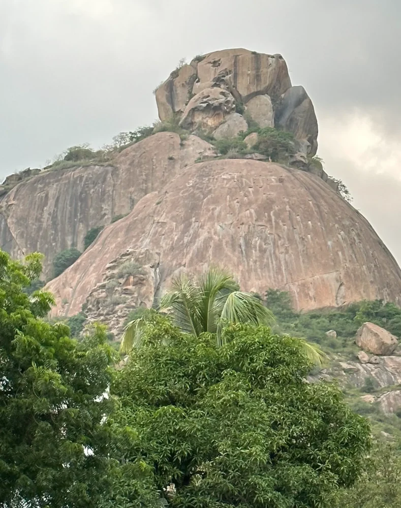
The Aravalli Range is one of the oldest mountain ranges in India, located primarily in Rajasthan. It is part of a larger structure known as the Indian Craton, which includes several cratons—stable parts of the Earth’s crust. The Aravalli Craton, also known as the Marwar-Mewar Craton, covers parts of Rajasthan and western Haryana.
Key Characteristics
Cratons
Cratons are stable areas of continental crust. The Aravalli Craton includes two main parts:
- Mewar Craton: Located in the east.
- Marwar Craton: Located in the west.
Boundaries
- East: Great Boundary Fault
- West: Thar Desert
- North: Indo-Gangetic alluvium
- South: Son, Narmada, and Tapti River basins
Rock Types
The Aravalli Range is made up of various types of rocks, including:
- Quartzite: A hard and durable rock.
- Marble: A beautiful, metamorphic rock often used for sculptures.
- Pelite: A fine-grained sedimentary rock.
- Greywacke: A type of sandstone with various minerals.
- Extinct Volcanoes: Remnants of ancient volcanic activity.
Malani Igneous Suite
The Malani Igneous Suite is a significant geological feature in the Aravalli Range. It is the largest igneous rock formation in India and the third largest in the world. The Geological Survey of India has declared it a National Geological Monument due to its unique features.
Tectonic Evolution
The Aravalli Range has undergone significant tectonic changes over millions of years. Here’s a brief timeline of its evolution:
- Neoproterozoic Era: Formation of the Marwar Group (500-550 million years ago).
- Mesoproterozoic Era: The Delhi Supergroup formed (1100-900 million years ago).
- Paleoproterozoic Era: Development of the Hindoli Group (1800-1700 million years ago).
- Archean Era: The oldest rocks, like the Mangalwar Complex and Mewar Gneiss, formed (2900-2600 million years ago).
Stratigraphic Classification
The Aravalli Range can be divided into different rock groups from north to south:
- Archean Basement: Includes gneissic rocks and schists.
- Aravalli Supergroup: Divides Rajasthan into two halves, with the highest peak, Guru Shikhar, reaching 5,650 feet (1,720 meters).
- Champaner Group: Made of various types of sedimentary rocks.
- Udaipur Group: Thick layers of greywacke and dolomite.
- Debari Group: Contains carbonates and quartzite.
- Delwara Group: Features a thick layer of volcanic conglomerate.
Unconformities
There are gaps in the geological record at various locations in the Aravalli Range, including:
- Mangalwar/Sandmata Complex
- Delhi Supergroup
- Haryana Aravalli Ranges: Located in western Haryana, featuring quartzite and other rocks.
Notable Hill Ranges
- Tosham Hill Range: The northernmost part of the Aravalli Range, containing quartzite and other rocks.
- Madhogarh Hill
- Satnali Hill
- Nuh-Ferozepur Jhirka Hill Range: Runs along the Haryana-Rajasthan border.
- Rajasthan Alwar Range: Found in the east.
The Aravalli Range is a geologically rich area with a fascinating history of rock formation and tectonic activity. Its unique features and long history make it an important natural landmark in India.
Climate of the Aravalli Range
The Aravalli Range spans several regions in India, and its climate varies significantly from north to south. Here’s an overview of the climate in different parts of the Aravalli Range:
Northern Aravalli Range (Delhi and Haryana)
- The climate here is a mix of humid subtropical and hot semi-arid continental.
- Summer: The temperatures can get very high, reaching between 40°C and 46°C (104°F to 115°F).
- Winter: The temperature drops to a cooler range of 1.5°C to 4°C.
- Characteristics: This region experiences:
- Dryness
- Extreme temperatures
- Scanty rainfall
Central Aravalli Range (Rajasthan)
- The climate in the central part of the Aravalli Range is classified as arid and dry.
- This area has limited rainfall and high temperatures, especially during the summer months.
Southern Aravalli Range (Gujarat)
- The climate in the southern part of the Aravalli Range is a tropical wet and dry climate.
- This region experiences a more distinct wet and dry season compared to the others, with more rainfall during the monsoon months.
Overall, the climate of the Aravalli Range shows a diverse range of conditions, from humid subtropical and hot semi-arid in the north to arid in the central region, and tropical wet and dry in the south.
Rivers of the Aravalli Range
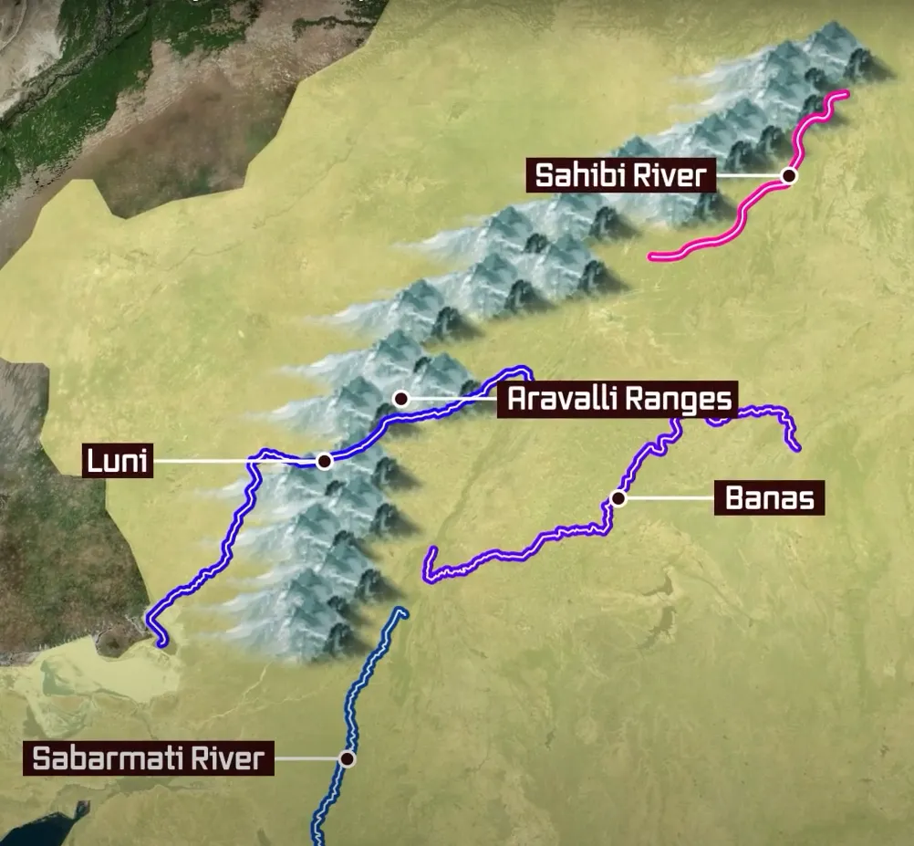
The Aravalli Range is the source of several important rivers and their tributaries. These rivers flow in various directions and play a significant role in the region’s geography and ecology.
Major Rivers Flowing from the Aravalli Range
1. Banas River
- Type: Northern-side tributary of the Chambal River.
- Origin: The Banas River originates in the Aravalli Range and flows through Rajasthan.
- Significance: It is important for irrigation and local agriculture.
2. Sahibi River
- Type: Tributary of the Yamuna River.
- Origin: The Sahibi River begins near Manoharpur in the Sikar district of Rajasthan.
- Flow: It flows through Haryana and eventually meets the Yamuna in Delhi, where it is known as the Najafgarh Drain.
- Tributaries:
- Dohan River: Originates near Neem Ka Thana and is a tributary of the Sahibi.
- Sota River: Merges with the Sahibi at Behror in the Alwar district.
- Krishnavati River: Previously a tributary of the Sahibi, it flows through various districts and has important wetlands in its paleochannel.
3. Luni River
- Origin: The Luni River starts in the Pushkar valley near Ajmer.
- Flow: It travels through the Thar Desert and ends in the marshy lands of the Rann of Kutch.
- Historical Significance: It was once part of the Saraswati River channel and has several Indus Valley Civilization sites along its banks, including Lothal.
4. Chambal River
- Type: Southern-side tributary of the Yamuna River.
- Flow: Originates in the Vindhya Range but is significant in the context of the Aravalli due to its tributaries.
Other Notable Rivers and Tributaries
West to North-East Flowing Rivers
These rivers originate from the eastern slopes of the Aravalli Range and flow northwards toward the Yamuna:
- Berach River: A southern-side tributary of the Banas River, originating in the Udaipur district.
- Ahar River: A right-side tributary of the Berach, it flows through Udaipur city and forms Lake Pichola.
- Wagli River, Wagon River, Gambhiri River, and Orai River: All are right-side tributaries of the Berach River.
West to North-West Flowing Rivers
These rivers flow from the western slopes of the Aravalli range and drain into southern Haryana:
- Sakhi River: Ends in the marshy lands of the Rann of Kutch.
- Sabarmati River: Originates in the western slopes of the Aravalli in the Udaipur district and flows into the Gulf of Khambhat in the Arabian Sea.
Ecological Importance
Many of these rivers have rich biodiversity and support various ecosystems, including wildlife sanctuaries and national parks. Important wetlands lie in the paleochannels of these rivers, enhancing the ecological value of the region.
Great Green Wall of India
The Great Green Wall of Aravalli
- The Great Green Wall of Aravalli is a planned green corridor that will stretch 1,600 kilometers long and 5 kilometers wide.
- This corridor will run from Gujarat to Delhi along the Aravalli range. It aims to connect to the Shivalik hill range.
- The goal is to plant 1.35 billion (or 135 crore) new native trees over the next 10 years. This effort is to restore the forest cover in the area.
- This project is inspired by the Great Green Wall of Sahara in Africa. It will help reduce pollution in the region.
- Currently, 51% of pollution comes from factories, 27% from vehicles, 8% from crop burning, and 5% from fireworks during Diwali.
- Although it has been proposed since the 1990s, as of 2024, the project is still in the planning stages.
Addressed an event to inaugurate the Aravali Green Wall initiative in Tikli, Gurugram.
— Bhupender Yadav (@byadavbjp) March 25, 2023
Under PM Shri @narendramodi ji, through various initiatives like single-use plastic ban, water conservation efforts and natural resources protection, India is moving to revive the Aravalis. pic.twitter.com/A3FkKr9cqd
Wildlife Corridor
Northern Aravalli Leopard and Wildlife Corridor
Importance of the Corridor
- The Sariska–Delhi leopard wildlife corridor (also called the Northern Aravalli leopard wildlife corridor) is about 200 kilometers long.
- It connects the Sariska Tiger Reserve in Rajasthan to the Delhi Ridge. This corridor is crucial for the habitat of Indian leopards and jackals.
Wildlife Tracking
- In January 2019, the Wildlife Institute of India started surveying leopards and other wildlife.
- They used pugmarks (animal footprints) and trap cameras to gather information. They also planned to track leopards and jackals using radio collars.
Threats to the Corridor
- Urban development, especially highways and railways, cuts through the Aravalli range and this wildlife corridor, making it dangerous for animals.
- Unfortunately, large areas of the Aravalli are not protected, leading to the deaths of over 10 leopards from January 2015 to January 2019.
Water Issues
- In Haryana, the Gurugram-Faridabad Aravalli hill forests face a lack of water, making it hard for wild animals to thrive.
- In 2018, the Haryana government used drones to conduct aerial surveys and dug 22 pits to store rainwater, but these often dried up in summer.
- In January 2019, they announced plans to connect these pits with pipelines to keep them filled.
Human Activity
- Unplanned urbanization and pollution from factories pose a significant threat to wildlife. Some officials deny the presence of animals like leopards to allow more development, which harms the environment.
Legal Issues
- In 2019, the Haryana government proposed an amendment to a law that would reduce the Natural Conservation Zones (NCZs) by 47% (about 60,000 acres).
- This would violate guidelines from the Supreme Court of India, which states that the Aravalli area is ecologically sensitive.
Southern Aravalli Leopard Wildlife Corridor
- This corridor runs from Sariska and Ranthambore to the Rann of Kutch National Park and Gir National Park in Gujarat.
Nature Reserves in the Aravalli Range
The Aravalli Range is home to various national parks, wildlife reserves, and forests, including:
- Delhi Ridge
- Sariska Tiger Reserve
- Ranthambore National Park
- Sultanpur National Park
- Asola Bhatti Wildlife Sanctuary
These areas are essential for preserving biodiversity and wildlife.
Rich Flora and Fauna
The Aravalli Range hosts diverse forests and wildlife. A 2017 survey found 14 species of animals in Haryana, including:
- Leopards
- Hyenas
- Jackals
- Nilgai (blue bull)
- Peafowl (peacocks)
These findings encouraged further wildlife studies and tracking in the region.
Environmental Concerns
- In 1992, some parts of the Aravalli were protected from mining due to ecological laws.
- The Supreme Court of India has since banned mining in these areas to safeguard the environment.
- Unfortunately, unregulated urban development and mining continue to threaten the ecosystem.
Economic Importance
- The Aravalli Range is the source of many rivers and has supported human settlements for thousands of years.
- Major infrastructure projects, like the Delhi–Mumbai Industrial Corridor, have brought economic benefits to the region.
Tourism Potential
- The Aravalli Range attracts many tourists due to its forests, wildlife, protected areas, and historical sites. This tourism industry is vital for the local economy.
Final Thoughts
The Aravalli Range faces significant challenges due to urbanization, pollution, and inadequate protection for wildlife. Efforts like the Great Green Wall of Aravalli and wildlife corridors are essential for preserving the environment and supporting biodiversity.
