Are you preparing for competitive exams and looking for a complete understanding of the Barak River System? In this article, we’ve got you covered! But first, have you ever wondered what makes this river system unique in India’s geography?
The Barak River System plays a crucial role in the northeastern part of India, and this article offers you a detailed breakdown. You will find everything from its origin and tributaries to its environmental significance. Alongside, you’ll get key facts and an easy-to-follow map, making it the ultimate resource for your exams.
Ready to explore further? Learn how the Barak River influences not only regional hydrology but also the ecosystems and economies surrounding it. Let’s explore this vital river system together!
✅ Explore the Complete List of Indian Geography Topics
Overview of the Barak River
- The Barak River, also known as the Meghna River, begins its journey in the Japvo Mountain located in the Manipur Hills at an elevation of 3,015 meters.
- Flowing south through rugged terrain, it travels towards Tipaimukh, which marks the tri-junction of Assam, Manipur, and Mizoram.
- At Tipaimukh, the river takes a sharp turn and enters the Cachar district of Assam, where it flows along the border of Assam and Manipur until reaching Jirimat, near Lakhimpur.
🔶 Also Explore
Krishna River System: Location, Map, Tributaries, Key Facts
Yamuna River, Origin, Catchment Area, Tributaries, Pollution
All About Mahanadi River System: Tributary, Dams, Project, Industry, Facts
Course Through the Barak Valley
- As the Barak River moves through the Barak Valley of Assam, it covers a distance of 564 kilometers before crossing into Bangladesh.
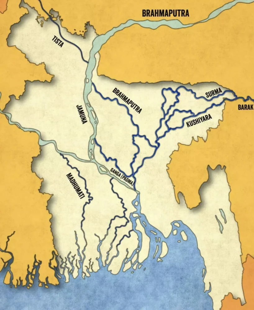
- Here, the river splits into two branches: the Surma and the Kushiyara. Eventually, these two streams merge to form the Meghna River, which later combines with the waters of the Ganga and Brahmaputra rivers, creating one of the largest river systems in the region.
The River’s Journey Across Borders
- In total, the Barak River stretches for 900 kilometers across Manipur, Mizoram, and Assam.
- Of this, 524 kilometers lie within India, while 31 kilometers serve as the boundary between India and Bangladesh. The remainder of the river flows through Bangladesh.
- The upper navigable section of the river, spanning 121 kilometers between Lakhipur and Bhanga, was declared National Waterway 6 (NW-6) in 2016.

The Barak River Basin
- The Barak River sub-basin covers an area of 52,000 square kilometers, with 41,723 square kilometers located in India—roughly 1.38% of the country’s land area.
- The sub-basin is bordered by the Barail Range to the north, which separates it from the Brahmaputra sub-basin, the Naga and Lushai Hills to the east, and Bangladesh to the south and west.
- This vast basin is spread across the states of Meghalaya, Manipur, Mizoram, Assam, Tripura, and Nagaland, making it a vital geographical feature in the region.
- The Barak sub-basin spans across India, Bangladesh, and Burma (Myanmar).
Key Tributaries
- The Barak River is fed by numerous tributaries, all located in India. These include the Irang, Tuivai, Sonai, Jiri, Tlawng, Katakhal (Dhaleshwari), Chiri, Rukni, Singla and Jatinga rivers. Some smaller streams like the Longai and Madhura also contribute to the river’s flow.
- The Barak River and its tributaries play a critical role in draining the local rainfall runoff from the valley and nearby hilly areas. The water is eventually carried into Bangladesh.
- These rivers are primarily rain-fed, and during heavy precipitation, they often contribute to flooding in the region.
Flow of the Barak River and Its Tributaries
- In Manipur, the Barak River flows southwest towards Tipaimukh, where it meets the Tuivai River.
- From Tipaimukh, the Barak turns northward and is joined by the Jiri River at Jirimukh.
- The river then moves westward, flowing through the Cachar and Karimganj districts of Assam, before entering Sylhet in Bangladesh.
- Once in Bangladesh, the Barak splits into two main distributaries: the Surma River and the Meghna River. The Surma eventually rejoins with the Meghna, which later merges with the Padma (the Ganga), contributing to the massive Ganga-Brahmaputra Delta.
Hydropower Potential
- The Barak River holds significant potential for hydropower generation, with an estimated capacity of 3,908 MW at a 60% load factor. This makes it a valuable resource for energy production in the region.
Major Infrastructure Projects
- Several key infrastructure projects are associated with the Barak River. The Tipaimukh Dam Project is one of the most notable, along with the Teesta Champamati and Dhansiri Barrages. These projects aim to harness the river’s flow for irrigation and flood control, while also generating power.
Challenges and Issues
- Flooding is a major issue in the Brahmaputra-Barak Basin, with nearly 4.33 million hectares of land being prone to floods annually. Additionally, erosion caused by the river affects many towns and villages, disrupting the lives of thousands of people.
Environmental Importance
Environmental Concerns: Impact on Aquatic Life
- Environmentalists are increasingly concerned about the destruction of aquatic habitats in the upper reaches of the Barak River in southern Assam.
- A leading conservation organization, the Society for Activists for Forest and Environment (SAFE), has highlighted a damaging practice adopted by the local tribal communities living along the riverbanks.
- These communities have started using small gelatin sticks, illegally smuggled from Mizoram, to kill fish. This method is extremely harmful, resulting in the death of thousands of fish, including both young and mature species, as well as other aquatic creatures such as turtles and dolphins.
The Threat to the Endangered Ganges River Dolphin
- One of the most alarming impacts of these destructive activities is on the Ganges river dolphin, an endangered species.
- The proposed Tipaimukh Dam on the Barak River in northeastern India has become a political flashpoint between India and Bangladesh.
Environmental researchers have warned that this dam could further accelerate the decline of the dolphin population, pushing it toward extinction.
- A study by researchers from Assam has raised a plea for urgent conservation efforts to protect India’s national aquatic animal, which is on the verge of local extinction in the state’s river systems.
- According to M.K. Mazumder, the lead author of the study, several factors are contributing to the dolphins’ decline, including poaching (for oil and meat), accidental deaths in fishing nets, habitat degradation caused by embankments and sluice gates, and disturbances from motorboats and aquatic pollution. These cumulative impacts have led to the disappearance of dolphins from the Barak River system in Assam.
Explore More Indian Geography Topics:
Important Water Reservoirs in India with Key Facts: Complete Guide
Renuka Lake: Key Details about Smallest Ramsar Wetland Sites of India
Keibul Lamjao National Park: The World’s Only Floating National Park


