Get ready to explore the exciting world of Indian geography as we take a closer look at the Indira Gandhi Canal! This amazing canal flows through the sunny state of Rajasthan and is a lifeline for farmers.
It’s also packed with important information that you need for your geography exams. Whether you’re preparing for competitive tests like UPSC, SSC, RRB NTPC, CDS, or WBCS, knowing about this canal is really important.
So, grab your pens and notepads as we share keynotes on the Indira Gandhi Canal that will help you understand its significance and improve your exam scores! Let’s get started!
✅ Explore the Complete List of Indian Geography Topics
Indira Gandhi Canal Overview
| Specifications | Details |
|---|---|
| Length | 650 km (400 miles) |
| Former Names | Rajasthan Canal |
| Construction Began | 1958 |
| Date of First Use | 2005 |
| Date Completed | Last portion finished in 2010 |
| Start Point | Harike Barrage, Punjab |
| End Point | Thar Desert, Rajasthan |
| Branch of | Sutlej, Beas |
| Connects to | Thar Desert |
Indira Gandhi Canal: India’s Longest Canal
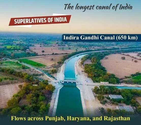
- The Indira Gandhi Canal, formerly called the Rajasthan Canal, holds the title of the longest canal in India.
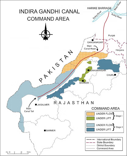
- Its journey begins at the Harike Barrage, located near the town of Harike, just a few kilometers downstream from where the Satluj and Beas rivers merge in Punjab.
- The canal extends across the vast northwestern region, ending in irrigation systems that serve the Thar Desert in Rajasthan.
- Initially named the Rajasthan Canal, it was later renamed the Indira Gandhi Canal on November 2, 1984, to honor the late Prime Minister Indira Gandhi following her tragic assassination.
- This canal plays a crucial role in transforming the barren lands of the Thar Desert, providing much-needed water for irrigation and sustaining agriculture in the region.
Structure of the Indira Gandhi Canal
- The Indira Gandhi Canal comprises two major sections: the Rajasthan Feeder Canal and the Rajasthan Main Canal.
- The Rajasthan Feeder Canal stretches for the first 167 kilometers (104 miles) through Punjab and Haryana, followed by an additional 37 kilometers (23 miles) in Rajasthan.
- Afterward, the Rajasthan Main Canal covers a length of 445 kilometers (277 miles) entirely within Rajasthan.
- The canal flows into Haryana from Punjab near Lohgarh, running through the western region of Sirsa district.
- It then enters Rajasthan near Kharakhera village in the Tibbi tehsil of Hanumangarh district.
- This extensive network supports irrigation across the arid lands of Rajasthan, boosting agriculture and livelihoods in these areas.

Path of the Indira Gandhi Canal in Rajasthan
- The Indira Gandhi Canal winds through seven districts of Rajasthan, bringing life to the arid regions of Barmer, Bikaner, Hanumangarh, Jaisalmer, Jodhpur, and Sriganganagar.
- The main canal stretches for 445 kilometers (277 miles), marked as 1458 RD (reduced distance).
- At this point, a 96-kilometer (60-mile) long offshoot, called the Sagar Mal Gopa Branch (SMGS), branches out.
- From the endpoint of the SMGS, another 92-kilometer sub-branch, known as the Baba Ramdev Sub-Branch, extends further.
- This sub-branch concludes near Gunjangarh village in the Jaisalmer district.
- This vast network of branches and sub-branches plays a pivotal role in irrigating the dry lands of Rajasthan, significantly contributing to the state’s agricultural development.
Origins and Vision Behind the Indira Gandhi Canal
- The concept of harnessing the waters from Himalayan rivers flowing through Punjab and into Pakistan was first envisioned in the late 1940s by renowned hydraulic engineer Kanwar Sain.
- Kanwar Sain estimated that nearly 2 million hectares (20,000 km²) of desert land in Bikaner and the northwest region of Jaisalmer could be transformed through irrigation using the stored waters of Punjab’s rivers.
- This vision gained momentum after the Indus Water Treaty was signed between India and Pakistan in 1960.
- The treaty allowed India the right to utilize the waters from three key rivers—the Satluj, Beas, and Ravi.
- The proposed Rajasthan Canal (now the Indira Gandhi Canal) aimed to make use of 7.6 million acre-feet (approximately 9.4 billion cubic meters) of water.
- This initiative was intended to bring much-needed irrigation to the desert regions of Rajasthan.
Construction Phases of the Indira Gandhi Canal
The original plan for the Indira Gandhi Canal was to develop it in two stages.
Stage I
- Stage I involved building a 204-kilometer (127-mile) feeder canal that would run from the Harike Barrage in Firozpur, Punjab, to Masitawali in Hanumangarh. This stage also included constructing the main canal, measuring 189 kilometers (117 miles), stretching from Masitawali to Pugal in Bikaner, Rajasthan.
- Additionally, a distributary canal system of approximately 2,950 kilometers (1,830 miles) in length was planned to distribute water across the regions.
Stage II
- Stage II aimed to create a 256-kilometer (159-mile) long main canal from Pugal to Mohangarh in Jaisalmer. This stage included an extensive distributary canal network measuring around 3,600 kilometers (2,200 miles).
- The design of the main canal specified that it would be 140 feet (43 meters) wide at the top and 116 feet (35 meters) wide at the bottom, with a water depth of 21 feet (6.4 meters).
- The ambitious project was scheduled for completion by 1971, with the goal of significantly enhancing irrigation in Rajasthan’s desert areas.
Challenges and Revisions in the Indira Gandhi Canal Project
- The Indira Gandhi Canal project encountered significant challenges, including severe financial constraints, neglect, and corruption.
- In 1970, the original plan was revised to address these issues, and it was decided that the entire canal would be lined with concrete tiles to improve its durability and efficiency.
- Five more lift schemes were introduced, enhancing the flow command of Stage II by 100,000 hectares (1,000 km²).
- As a result of these increased requirements, the total length of the main, feeder, and distribution canals expanded to approximately 9,245 kilometers (5,745 miles).
- Despite these revisions and enhancements, Stage I of the canal was ultimately completed in 1983, about 20 years behind the original completion schedule.
- This delay highlighted the difficulties faced during the construction and management of such a vast and complex irrigation project.

Impact of the Indira Gandhi Canal on Irrigation
- The Indira Gandhi Canal significantly expanded irrigation facilities, covering an area of 6,770 km² (1,670,000 acres) in the Jaisalmer district and 37 km² (9,100 acres) in the Barmer district.
- Before the canal’s completion, irrigation had already been established over 3,670 km² (910,000 acres) in Jaisalmer.
- The canal has facilitated the cultivation of crops such as mustard, cotton, and wheat in this semi-arid northwestern region.
- The canal has transformed the landscape and enhanced agricultural productivity in the area.
- Despite these advancements, there is ongoing debate regarding the overall success of the canal in arid areas.
- Many experts question whether the canal has truly achieved its intended goals, raising concerns about its long-term sustainability and effectiveness in such challenging environments.


