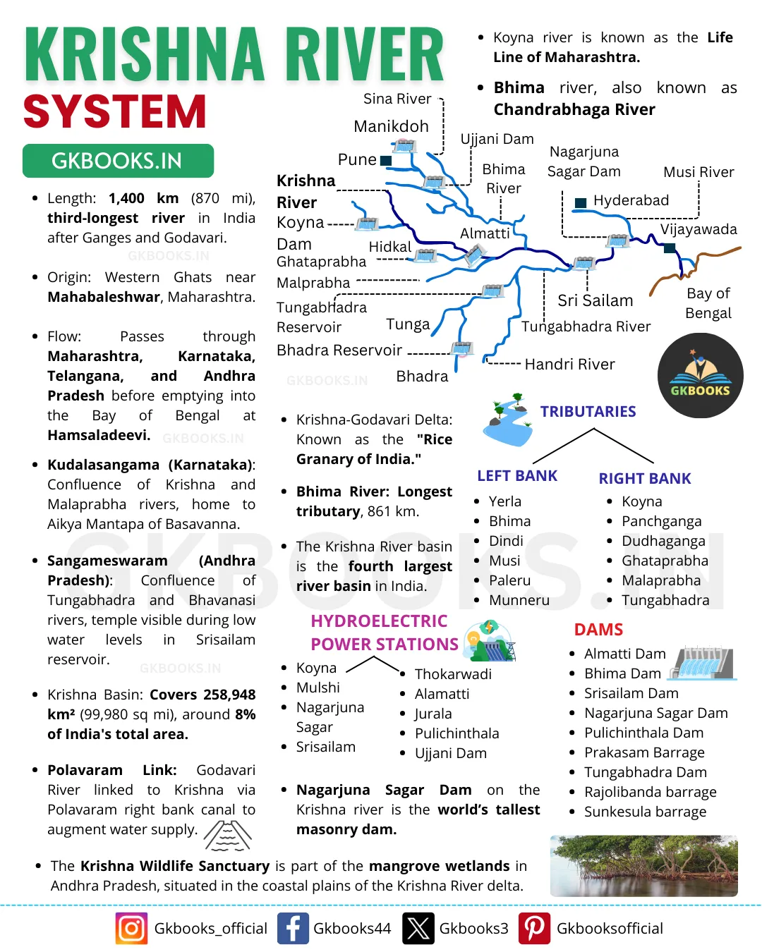
Are you preparing for competitive exams like SSC, RRB, NTPC, or UPSC? The Krishna River System is an essential topic that often appears in these tests. In this post, we’ll cover its location, map, tributaries, and key facts to help you stay ahead. Ready to dive into one of India’s major river systems?
The Krishna River stretches over 1,400 kilometers, flowing through Maharashtra, Karnataka, Telangana, and Andhra Pradesh. With major tributaries like Tungabhadra and Bhima, this river system plays a vital role in agriculture and water management. This article provides a clear understanding of its significance for exam preparation.
But there’s much more to explore! From its historical importance to its modern-day uses, we’ve got everything covered. So, without further delay, let’s get into the fascinating details of the Krishna River System that will boost your competitive exam knowledge.
✅ Explore the Complete List of Indian Geography Topics
Krishna River Overview
The Krishna River is the second-largest east-flowing river in the Indian Peninsula. It originates at Mahabaleshwar, located at an altitude of 1,336 meters near Jor village in the Satara District of Maharashtra. From its source, the river flows eastwards and eventually empties into the Bay of Bengal in Andhra Pradesh.
Ecologically, the Krishna River is known for causing significant soil erosion during the monsoon season, making it one of the more problematic rivers in the world regarding environmental impact.
Geographically, the Krishna River is bordered by the Balaghat Range to the north, the Eastern Ghats to the south and east, and the Western Ghats to the west.
The river stretches 1,400 kilometers from its source to its mouth at the Bay of Bengal. Approximately 75.86% of its basin area is covered by agricultural land, highlighting its importance for farming.
The Krishna River forms a large delta with a shoreline of about 120 kilometers. Several major dams have been constructed along the river, including the Almatti Dam, Srisailam Dam, Nagarjuna Sagar Dam, and Prakasam Barrage.
Due to its dependence on seasonal monsoon rains, the Krishna River experiences significant fluctuations in flow throughout the year, which can limit its effectiveness for irrigation.
Key urban and tourist centers along the river include Satara, Karad, Sangli, Bagalkot, Srisailam, Amaravati, and Vijayawada.

Follow our official Facebook page for the latest and most up-to-date infographics! – Gkbooks44
Major Tributaries of Krishna River
The Krishna River is fed by several important tributaries from both its right and left banks.
Right Bank Tributaries
- Venna
- Koyna: Although a small tributary, the Koyna River is notable for the Koyna Dam. The dam was linked to the devastating earthquake in 1967, which measured 6.4 on the Richter scale and resulted in 150 deaths.
- Panchganga
- Dudhganga
- Ghataprabha
- Malaprabha
- Tungabhadra: Formed by the confluence of the Tunga and Bhadra rivers, originating from Gangamula in the Central Sahyadri. It has a total length of 531 kilometers.
Left Bank Tributaries
- Bhima: Originates from the Matheron Hills and flows for 861 kilometers before joining the Krishna River near Raichur.
- Dindi
- Peddavagu
- Halia
- Musi: Receives its last important tributary, the Musi River, at Wazirabad. Hyderabad is located along the banks of the Musi River.
- Paleru
- Munneru
These tributaries play a crucial role in contributing to the flow and water resources of the Krishna River.
Also Explore: Krishna River One-liners Questions and Answers: Krishna River FAQs
Bhima River
- The Bhima River originates in the Bhimashankar Hills, located near Karjat on the western side of the Western Ghats (Sahyadri) in Maharashtra.
- The river flows southeastward for 725 kilometers, passing through the states of Maharashtra, Karnataka, and Andhra Pradesh.
Several significant temples are situated along the banks of the Bhima River, including:
- Bhimashankar Temple: One of the twelve revered Jyotirlinga shrines.
- Siddhatek Temple: Part of the Ashtavinayak pilgrimage, dedicated to Ganesh.
- Siddhivinayak Temple: Another key Ganesh temple in the Ashtavinayak series.
- Pandharpur Vithoba Temple: A major pilgrimage site dedicated to Vithoba.
- Sri Dattatreya Temple: Known for its religious significance.
- Sri Kshetra Rasangi Balibheemasena Temple: An important temple along the river.
- These temples contribute to the river’s cultural and spiritual significance.
Musi River
- The Musi River, historically known as the Muchukunda River, is a key tributary of the Krishna River. It originates in the Anantagiri Hills near Vikarabad in the Rangareddi district, approximately 90 kilometers west of Hyderabad.
- In 1920, the Osmansagar Reservoir was constructed across the Musi River at Gandipet village, creating a vital water resource for the region. Additionally, the Himayat Sagar Dam and Hussain Sagar Lake, built on a tributary of the Musi River, further contribute to the water supply for Hyderabad.
The Musi River is also a focal point for various water festivals, including:
- Boating Races
- Decorated Boating Contests
- River Swimming Tournaments
These events highlight the river’s importance to the local community and its role in recreational activities.
Koyna River
- The Koyna River originates in Mahabaleshwar, located in the Satara district of Maharashtra. It is a significant tributary of the Krishna River.
- Unlike most rivers in Maharashtra that flow in an east-west direction, the Koyna River flows from north to south.
- The river is renowned for the Koyna Dam, which is the largest hydroelectric project in Maharashtra. The dam creates Shivasagar Lake, a vast reservoir stretching 50 kilometers in length.
- Situated in Koyna Nagar within the Western Ghats, the dam plays a crucial role in generating hydroelectric power and managing water resources. The Koyna River joins the Krishna River at Karad.
- The river itself is about 100 meters wide and has a relatively slow flow.
Panchganga River
- The Panchganga River flows through the Kolhapur region and is formed by the confluence of four streams: Kasari, Kumbhi, Tulsi, and Bhogawati.
- The river officially begins at the Prayag Sangam, where these four tributaries merge. After this confluence, the Panchganga River expands and continues its journey, incorporating the flow from these tributaries.
- North of Kolhapur, the river traverses a wide alluvial plain, where it spreads out before resuming its course eastward. The Panchganga River ultimately joins the Krishna River at Kurundvad.
Dudhganga River
- The Dudhganga River is a right-bank tributary of the Krishna River and plays a significant role in the Kolhapur district of Maharashtra.
- An important infrastructure project on this river is the Kallammawadi Dam, constructed with collaboration from the Karnataka State. This dam is crucial for water management and irrigation in the region.
Ghataprabha River
- The Ghataprabha River originates in the Western Ghats at an altitude of 884 meters. It flows eastward for 283 kilometers through the states of Karnataka and Maharashtra before joining the Krishna River at Almatti.
- One of the river’s highlights is the Gokak Waterfall, located in the Belgaum District, which is a popular tourist attraction.
- The Ghataprabha Project is a significant hydroelectric and irrigation dam built across the river, contributing to the region’s water management and power supply.
Malaprabha River
- The Malaprabha River originates in Kanakumbi, situated in the Belgaum District of Karnataka, at an elevation of 792 meters in the Sahyadri range.
- It flows for 304 kilometers before joining the Krishna River at Kudalasangama in the Bagalkot District, where it descends to an altitude of 488 meters.
- The Navilatirtha Dam, located near Munavalli in the Belgaum District, spans across the Malaprabha River, creating the Renukasagara reservoir.
- The river is also famous for its historical temples along its banks, including Aihole, Pattadakal, and Badami. These temples are celebrated for their architectural heritage and have been designated as UNESCO World Heritage Sites.
Tungabhadra River
- The Tungabhadra River, historically known as Pampa, is a significant river in southern India.
- After merging, the Tungabhadra River travels across the plains for 531 kilometers before joining the Krishna River at Gondimalla, close to the notable Alampur Junction in the Mahabubnagar District of Andhra Pradesh.
- Key tributaries of the Tungabhadra include Varada, Hagari, and Handri.
- The region north of the Tungabhadra River, situated between the Tungabhadra and Krishna rivers, is known as the Raichur Doab.
- Major urban centers along the Tungabhadra include Harihar, Hospet, Hampi, Mantralayam, and Kurnool. These cities are important for their historical, cultural, and economic contributions to the region.
Major Projects and Hydropower Stations in the Krishna Basin
Several important projects and hydropower stations are located within the Krishna Basin, contributing significantly to the region’s infrastructure and development.
Key Projects
- Tungabhadra Project: This major inter-state project involves cooperation between Karnataka and Andhra Pradesh. It focuses on hydroelectric power generation, irrigation, municipal water supply, and flood control. The dam is situated across the Tungabhadra River near Hospet in Karnataka.
- Srisailam Project: A significant project involving a large dam built across the Krishna River in Kurnool district, Andhra Pradesh. The reservoir created is known as Srisailam Sagar or Neelam Sanjjeva Reddy Sagar, providing vital irrigation and hydroelectric power.
- Nagarjuna Sagar Dam: Initiated in 1950, this dam is one of India’s earliest large-scale infrastructure projects. It spans the Krishna River, straddling the borders of Nalgonda and Guntur districts, and was instrumental in the Green Revolution.
- Prakasam Barrage: Designed by Major Cotton of the East India Company, this barrage is constructed across the Krishna River near Vijayawada in Andhra Pradesh, aiding in flood control and irrigation.
- Ghataprabha Project: Located across the Ghataprabha River near Chandgad in Kolhapur district, Maharashtra, this project focuses on water resource management and irrigation.
- Bhima Project: Situated across the Bhima River in Solapur district, Maharashtra, this project enhances water availability and supports agricultural activities.
Major Hydropower Stations
- Koyna: Known for its significant contribution to the region’s power supply.
- Tungabhadra: Another key station that supports hydroelectric power generation.
- Sri Sailam: A major facility for both power and water supply.
- Nagarjuna Sagar: Plays a crucial role in power generation and irrigation.
- Almatti: Adds to the region’s hydropower capabilities.
- Naryanpur: Contributes to the basin’s overall hydropower production.
- Bhadra: Supports both irrigation and power needs.
These projects and stations are vital for managing water resources, supporting agriculture, and providing electricity across the Krishna Basin.
Industrial Potential in the Krishna Basin
- The Krishna Basin is rich in mineral deposits, offering significant opportunities for industrial development. Currently, the basin supports a range of important industries, including iron and steel production, cement manufacturing, sugar processing, vegetable oil extraction, and rice milling.
- A recent discovery of oil in the basin is expected to greatly impact the region’s future industrial landscape. This new development could lead to increased economic growth and further industrial expansion in the area.
Industry in the Krishna Basin
- The Krishna Basin is home to several major urban centers, including Pune and Hyderabad.
- Hyderabad, the capital of Telangana, has become a key hub for the information technology (IT) industry, attracting many tech companies and professionals.
- Pune, located in Maharashtra, is known for its thriving automobile and IT industries. In addition to its industrial growth, Pune is also recognized as a major center for education, with numerous universities and educational institutions.
Drought and Floods in the Krishna Basin
Several regions within the Krishna Basin are prone to drought. Areas like Rayalaseema in Andhra Pradesh, and districts such as Bellary, Raichur, Dharwad, Chitradurga, Belgaum, and Bijapur in Karnataka, along with Pune, Solapur, Osmanabad, and Ahmednagar in Maharashtra, often experience water shortages and dry conditions.
On the other hand, the delta region of the Krishna Basin faces frequent flooding. The continuous deposition of silt in the riverbed raises its level, reducing the river’s ability to carry water effectively. This makes the area more vulnerable to floods.
Additionally, coastal cyclones bring intense rainfall over short periods, further worsening the flood situation in the delta.


